
Why I Built MapMonkey

I love Strava. I love it so much I’ve turned off every alert it sends me — I don’t need a notification every time someone I know posts an activity. I’ve been on it a long time too. Strava user #15971, if you’re wondering, which tells you something about how long I’ve been cycling — over twenty years now. Being retired these days means I get to do a lot more multi-day rides than I used to, which is where this whole thing started.
Landing overseas? Sort your data first
An eSIM installs before you fly — no local SIM queue, no roaming bill.
Code: DREWDEAL (enter manually at checkout)
(Small referral our way if you use our link — doesn’t change your price.)
The feature I actually love — the one I open Strava for when I’m not even riding — is the map. The heatmap that quietly builds up over time, showing every place you’ve walked, skied, cycled, paddled. (Worth knowing: it’s a paid-subscription feature, not something you get on the free tier — but it’s the one upgrade I’d defend to anyone.) A paddling buddy of mine loves his so much he’s got it set as his work screensaver, updated weekly. Sydney Harbour, on his screen, is basically just a solid blue blob at this point from how much he’s out on it.
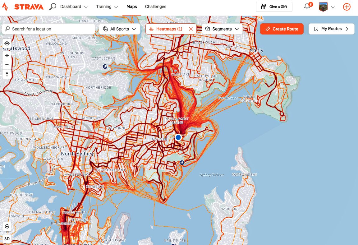
I’ve got the same thing for cycling in Europe — thousands of kilometres over several trips. Except mine has a problem: at that scale, it starts disappearing.
Why Strava’s Heatmap Doesn’t Work for Multi-Day Cycling Trips
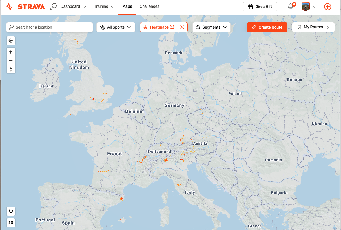
Strava’s map is built for showing you where you’ve been near home. Zoom out far enough to see an entire multi-day European crossing, and some simple UX choices start working against you — routes overlap, lines get too thin to read, days blur into each other, and thousands of kilometres of actual riding just fade into the background instead of standing out as the achievement it was.
The other thing that quietly annoys me: try sharing a Strava file with someone who doesn’t have an account. It’s clunky. My riding mates all have Strava, but not everyone I want to show a trip to does — family, non-cycling friends, people in a Facebook group who just want to see the route without signing up for anything.
And the thing I actually wanted, more than either of those — I like connecting the individual rides of a trip together into one beautiful, single experience. Not six separate activities sitting in a feed, but one story: day one, day two, day three, the whole journey, side by side, colour-coded, so you can see the whole shape of it at a glance and actually share that with someone in one go.
None of that exists in Strava. So I built it.
How it got built
I’m not a coder. I’m a retired banking exec who took up cycling seriously in retirement and started building apps with AI assistance because I got tired of waiting for someone else to build the thing I wanted. MapMonkey is the latest of those — built the same way as everything else in the MyMonkeyApps stable, sitting on Firebase, no login wall, no subscription, just upload and go.
Using AI to build like this is a bit like having the team I used to have at work — except this team doesn’t need offsites, doesn’t need positive reinforcement, and doesn’t get precious about feedback. Just clear direction and a lot of testing. You say “no, not like that,” you say why, and it goes again. That’s genuinely most of the job.
How MapMonkey Turns Your GPX Files Into One Shareable Cycling Map
Grab a whole folder of GPX files off your laptop and drop them in together — not one at a time, the lot in one go. Each one becomes its own leg, gets its own colour, its own name, and you can reorder them into whatever sequence the trip actually happened in. The map draws the whole route, the elevation chart sits underneath it, and hovering over the chart moves a little marker along the map so you can see exactly where that gut-punch climb happened.
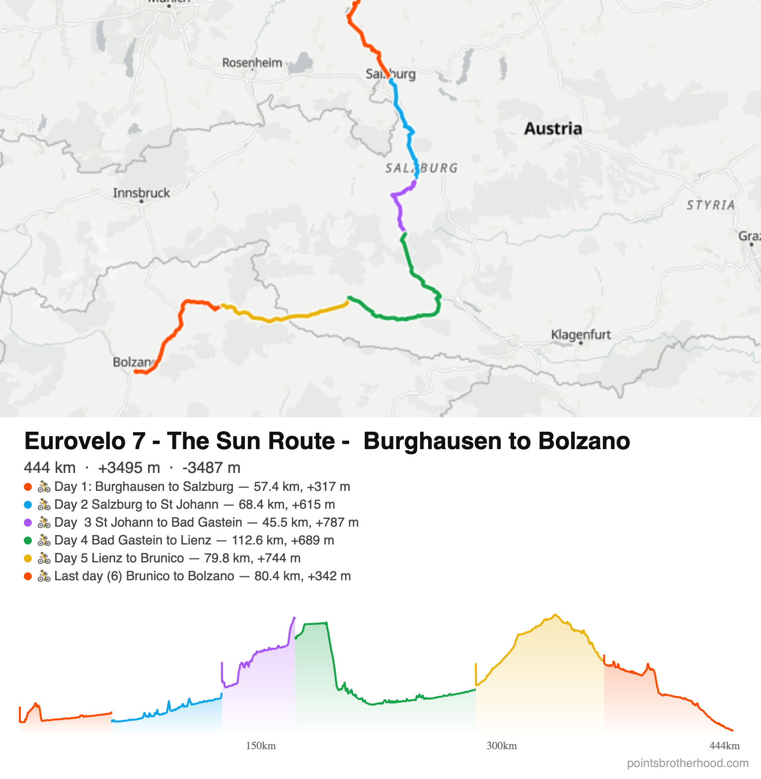
When you’re happy with it, you can export the whole thing as a single image — map, stats, elevation profile, all in one — or generate a share link if you’d rather send something interactive. Either way, no account needed, and nothing you upload goes anywhere unless you choose to share it.
✈️ Heading somewhere? Sort your data before you fly.
We may earn a commission.
Why it’s got an eSIM strip on it
Multi-day trips are exactly when you actually need mobile data — navigating unfamiliar towns, checking the next day’s forecast, messaging home to say you survived the climb. So there’s a small Airalo eSIM prompt built into the app itself too. I use Airalo myself on every one of these trips (the EuroVelo 7 crossing, the Japan ride, the Dordogne week — all run on it), and if it’s useful to you too, there’s a discount code above. Full transparency: I earn a small commission if you use it, which is what keeps me building these things instead of just complaining that they don’t exist.
What it’s not
It’s not trying to replace Strava — I still use Strava for everything MapMonkey doesn’t do. It doesn’t book anything, it doesn’t suggest routes, and it doesn’t sync across your devices unless you save the share link somewhere. It’s a “make my trip look as good as it felt, at whatever scale I want” tool, nothing more.
Where I’d like it to go
Right now it’s a map and an export button, and that’s genuinely all it needs to be for the moment. But the longer-term itch is wall art — I want a proper printed map of everywhere I’ve cycled in Europe hanging on a wall, not buried in an app I have to open and zoom out on to appreciate. That’s further down the track. Baby steps.
More Multi-Day Cycling Guides
If this has put you in a multi-day-trip mood, a few of my own are already written up:
- EuroVelo 7: Burghausen to Bolzano — the route in the maps above
- Shimanami Kaido & Nakasendo, Japan
- 7 days on two wheels: Bordeaux and the Dordogne
- Munich gravel cycling
- Top 5 gravel rides from Melbourne
- Four top gravel cycling rail trails near Melbourne
- Sydney cycling climbs
If you’ve got a multi-day trip sitting in a folder of unglamorous GPX files, give it a run: mapmonkey.web.app
MapMonkey FAQ: Free GPX Route Mapping Tool
Is there a free alternative to Strava’s heatmap for multi-day trips?
Yes — MapMonkey is free and built specifically for the gap Strava’s heatmap leaves open. Strava’s heatmap is great up close, but zoom out to a multi-day international trip and it becomes a tangle of thin, hard-to-read lines. MapMonkey keeps each day colour-coded and readable at any zoom level, and unlike the Strava heatmap, it’s not locked behind a paid subscription.
Does MapMonkey work with Strava GPX exports?
Yes. Export any activity from Strava as a GPX file and upload it straight into MapMonkey — no conversion needed.
Does MapMonkey work with Garmin, Komoot, or RideWithGPS files?
Yes. Any GPX export from Garmin Connect, Komoot, RideWithGPS, or most other ride-tracking apps and cycling computers will work the same way.
Is MapMonkey free?
Yes, completely free. No subscription, no paywall, no premium tier — unlike Strava, where the heatmap and route-building tools sit behind a paid plan.
Do I need to create an account, unlike Strava or Garmin Connect?
No. There’s no login wall — just open the app and upload your GPX files.
Does MapMonkey work on mobile?
Yes. You can view, upload, export, and reorder the days of a multi-leg trip on mobile using simple move up/down controls — no drag-and-drop needed.
Can I map a multi-day trip, not just a single ride like on Strava?
Yes — that’s the main reason MapMonkey exists. Upload one GPX file per day (or per leg), and they’ll each get their own colour and can be reordered into the sequence your trip actually happened in, shown together as one connected map and elevation profile, instead of sitting as separate activities in a feed.
Can I upload several GPX files at once?
Yes — drag in a whole folder at once rather than uploading one file at a time.
Can I share a trip with someone who doesn’t use Strava or MapMonkey?
Yes. You can export the whole thing as a single image, or generate a share link that opens for anyone — no account, app, or Strava login required on their end. This is easier than sharing a Strava activity with someone outside the platform.
Can I delete a trip I’ve shared?
Yes — you can delete any trip you’ve shared from your own profile in the app.
Does MapMonkey work offline?
It can be installed as an app on your phone or desktop (it’s a PWA), which allows some offline access, but uploading and sharing new trips requires an internet connection.

Planning this trip? Sort your data before you land
An eSIM is a digital SIM you install on your phone before you fly — no swapping a physical card, no local SIM queue when you land, no roaming bill shock.
Airalo covers 200+ destinations — up to 15% off with our link
Codes: DREWDEALNEW (new users) · DREWDEAL (existing users)
(Small referral our way if you use our link — doesn’t change your price.)