
Sydney International Airport By Foot – A Walk In The Park

Last updated: May 2026
The walk from Wolli Creek Station to Sydney International Airport is surprisingly pleasant (unlike the $17.92 per person access fee at the Airport station). It’s also pretty easy.
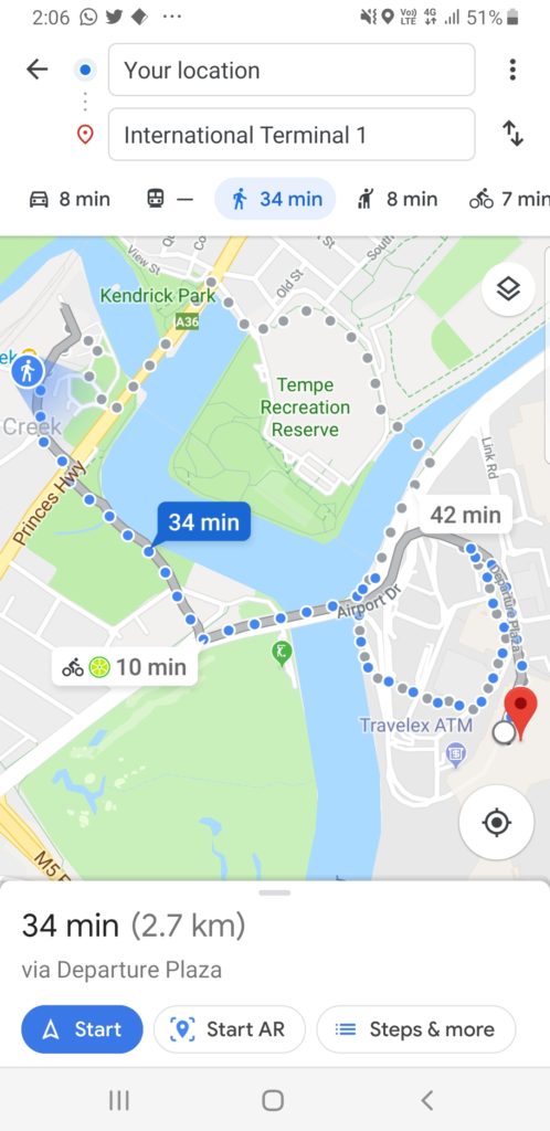
According to Google Maps, it’s a 2.7 km walk that will take over 33 minutes. The reality is quite different. I met my flying friends, David and Alan, to test it out. It turned out to be just under 2 km and took around 25 minutes. That’s at least partly due to a brand new, shared cycle way that Google Maps doesn’t know about yet. I’ve captured the walk on Strava, showing the more direct route.
📍 Updated May 2026 — we walked this route again this week
- The path is still hard to find at the airport — outside of arrivals cross the road and head up to the bike storage. You will find the shared bike path and signes to Woolli Creek.
- Its still a pretty walk. You follow the much cleaner Cooks River to the parks of Woolli Creek..
- Wolli Creek has gentrified. The precinct is now has cafes, shops and more, the area is well maintained and easy to navigate.
- Ignore the SIM card hawkers and FX ATMs when you arrive at the terminal. Both offer poor value. Sort your travel data before you leave home →
- New Strava route below — updated 2026 recording replacing the original.
To get to Wolli Creek station, you can catch either the Airport line (getting off at the stop after International) or the Illawarra line, whichever suits you best.
From Wolli Creek to Sydney International Airport
Wolli Creek station is quite new. This means that there are lifts, making it easier to get your bags off the platform. Once you are out of the station, cross the pedestrian crossing and turn left towards Woolworths.
Stay on the Woolworths side, as you’ll need to cross over the Princess Highway to Cahill Park. You then follow the waterway through the park. There’s a short deviation around the rowing club before you turn left over the Marsh Street Bridge.
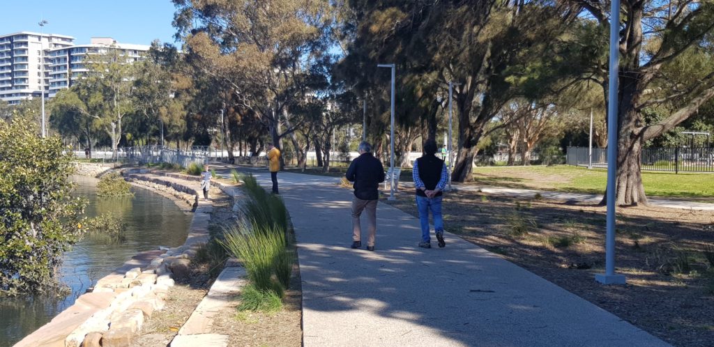
Once over the bridge, follow the underpass along the shared bright blue cycleway, with the Cooks River to your right and the Airport straight ahead.
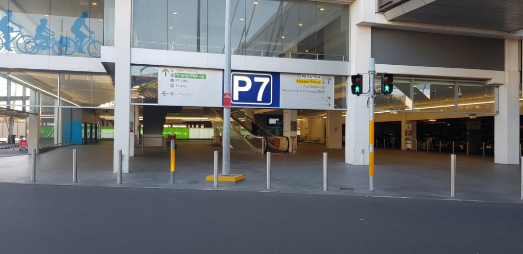
You’ll then emerge from car park number 7, immediately in front of the arrivals hall.
Tip: If you are walking from the Airport to Wolli Creek, head into the P7 car park. Go up one level, past the bike storage area and then follow the bike path signs. This is not signposted at all.
The walk is quite flat, on well-formed paths. It would be very realistic to drag your baggage over the distance. Much better than the cobbled streets of Europe!
On the walk we saw a few employees returning from the Airport, but no one who looked like an international passenger.
Wolli Creek or Tempe?
We walked to Tempe on the way back. It’s a longer walk and the second half of the walk couldn’t be described as scenic. There’s no disabled access at the station and there are fewer trains. It’s a no-brainer: consider Tempe only briefly and then head to Wolli Creek.
Summary: We were surprised at how scenic the walk was, particularly when compared with the Mascot to Sydney Domestic Terminal Walk. This could be a great way to tire your legs before a big flight or to start your jet lag recovery. If you have the time and it’s a sunny day, the consensus from David, Alan and myself was that we’d really consider it.
Getting between terminals or prefer the bus?
- Sydney Airport bus guide — the 420 and 350 from Mascot
- Getting between Sydney Airport terminals — domestic to international
- Every lounge at Sydney Airport — who gets in and how
Frequently asked questions
How far is it from Wolli Creek station to Sydney International Airport?
Just under 2km along the shared Cooks River cycleway. Google Maps overestimates the distance — it shows 2.7km because it doesn’t know about the shared bike path shortcut that was built after the original route was mapped.
How long does the walk from Wolli Creek to Sydney International Airport take?
Around 25 minutes at a comfortable pace. The route is completely flat with no hills or stairs on the path itself. Annie, one of our readers, did it in 22 minutes. Allow 30 minutes if you’re dragging luggage.
How much do I save by walking instead of taking the train?
The airport station access fee is currently $17.92 per adult per trip (Opal card rate). The walk from Wolli Creek costs only the standard Opal fare to Wolli Creek station — no airport surcharge.
Is the walk suitable for luggage?
Yes — the path is concrete and flat the whole way, with no cobblestones or significant kerbs. A carry-on roller bag is very manageable. A large checked bag on wheels is possible but will slow you down. CJ, one of our readers, did the return walk with his wife with luggage and called it “a breeze.” If you’re travelling with multiple large bags, the bus is a better option.
Can I walk from Sydney Domestic Airport to Sydney International Airport?
No — the distance between terminals is too far and the route between them is unattractive. The best option is the 420 bus, which takes 10 minutes between terminals and costs a standard Opal fare (no airport access surcharge). Full details in our Sydney Airport terminal transfer guide →
Can I walk from Wolli Creek to the domestic terminals?
The Wolli Creek walk goes to the international terminal (T1) only. For the domestic terminals (T2 Virgin, T3 Qantas), the walk from Mascot station is the better option — 1.6km and about 21 minutes. Full details in our Sydney Domestic Airport walking guide →
Is there a bus alternative to the walk?
Yes — the 420 bus from Mascot station goes to the international terminal in 17 minutes. It’s a standard Opal fare with no airport access surcharge, and the bus stop at international is actually closer to the departures entrance than the train station. Full details in our Sydney Airport bus guide →
What’s the Wolli Creek or Tempe question?
We tested both. Tempe is longer, less scenic, has no disabled access and fewer train services. Wolli Creek wins every time — it’s not a close call.
Is the walk safe?
Yes. The path runs through Cahill Park and along the Cooks River cycleway — a well-used public path in daylight hours. We’ve walked it at various times of day without issue. As with any urban walk, use common sense with your surroundings, particularly early morning or late at night.

Love the tip 👍 And if you could include a nearby cafe to spend your savings on that would also be great!
We had a $1 frozen coke at McDonalds… that left us $14 to spend…
Thanks Points Brotherhood
If coming from domestic airport and want to walk to Wooli station could u please describe how u get onto the path. I know I should work it out in reverse from your description but can’t quite do it.
I did the walk to Wooli a number of times 20 yrs ago when it was just a dirt track, used by airport employees so am delighted to see it’s still accessible and even upgraded.
Hi Leonie, I have only walked to the International Airport to Wooli Creek and not the domestic airport.
Followed these instructions and made it in 22 mins from Wolli creek – saved $16!
Thankyou so much Drew! I tried to find a walking route on my own – it was a nightmare. Your instructions saved the day!
My wife and I walked to the airport, then from the airport, using Wooli Creek station. It was a breeze. Concrete path all the way, and very little gradient. Good weather and a comfortable pair of shoes, and only one piece of luggage to drag along, made it very achievable for those of us with average health. Well done for providing pedestrian access without the fees, especially for the 1,000s who work there.