
New England Explorer: A 4-Day Bikepacking Loop from Quirindi via Nundle and Tamworth

This Tamworth bikepacking loop is a four-day ride that starts and finishes in Quirindi. It climbs over Lindsay Gap to Nundle, follows Chaffey Dam and the farming country around Woolomin, then rolls into Tamworth before a long gravel day back. It’s 264 km in total with about 2,600 m of climbing, mostly on good gravel and quiet back roads.
We had wool mill tours, a monthly-ish country market, two free campgrounds, an excellent milkshake and one very average one. Here’s how each day went, how the gravel rated, and where to eat.
The full route, with the elevation profile for each day, is on MapMonkey if you want to copy it.
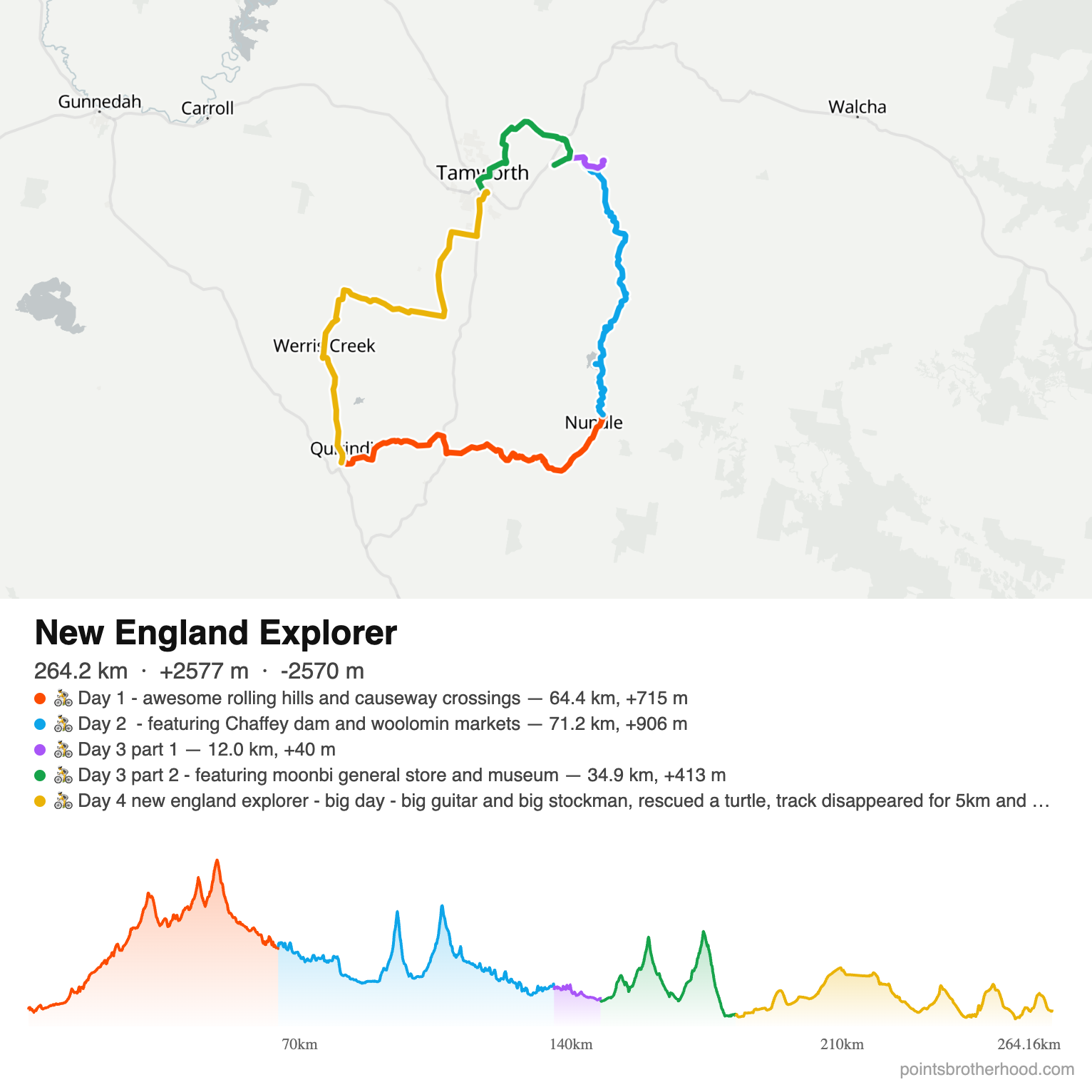
Open the full route in MapMonkey — zoom in, check each day’s elevation and follow it yourself.

Points Brotherhood exclusive — up to 15% off Airalo
Set up before you fly · discount applies automatically at checkout
Codes: DREWDEALNEW (new users) · DREWDEAL (existing users)
(Small referral our way if you use our link — doesn’t change your price.)
The Route at a Glance
| Day | Route | Distance | Climbing | Overnight |
|---|---|---|---|---|
| 1 | Quirindi → Lindsay Gap → Nundle | 64 km | 715 m | Free campground near Nundle |
| 2 | Nundle → Chaffey Dam → Woolomin | 71 km | 906 m | Cockburn River bush camp |
| 3 | Kootingal → Moonbi → Tamworth | 47 km | 453 m | Tamworth caravan park |
| 4 | Tamworth → Currabubula → Werris Creek → Quirindi | 82 km | ~500 m | Drive home |
Total: 264 km, +2,577 m. Best on a gravel bike — a few causeways and one stretch of track that’s barely there.
We parked outside the Quirindi police station for the four days. Not a guarantee, but it’s the spot we’d pick again for leaving a car unattended.
Day 1: Quirindi to Nundle via Lindsay Gap
First stop was the Quirindi bakery, which was flat out at lunchtime on a Friday. The pies were the popular choice but we went for fresh sandwiches: $6.50 for a packed salad sandwich, or $10.50 with silverside, deli meats and cheese. Good value either way.
The first 20 km follows the Seven Creeks track, well-graded gravel through the foothills of the Great Dividing Range. We’d give it 8/10. We stopped by a creek about 10 km in to eat our sandwiches. The causeways are rocky, so there’s no getting across without wet feet. I took my shoes off for the first one. As the name suggests, there are seven.
Next came 3 km on the New England Highway. I was worried about this bit, but there’s a wide shoulder and traffic was light. We then turned towards Nundle, rode a few kilometres of bitumen and turned off onto the gravel climb over Lindsay Gap.
This was hard work. It was 30 degrees, I needed a lot of breaks, and we hadn’t packed enough water. Once you’re over the gap, though, it’s a glorious descent and then bitumen into Nundle through beautiful farmland.
Carry more water than you think for Lindsay Gap, especially on a hot day. Electrolyte powder would have made this section a lot more pleasant.
In Nundle we called into the Nundle Woollen Mill, one of the only mills still doing all of its processing in Australia. We arrived at 5pm, but the owner was still there and kindly showed us around. Some of the machinery dates back to the early 1900s, and watching the wool being drawn out into yarn was the highlight of the day.
Dinner was at the Nundle Hotel. I’d go back for the burger or the pie, and the beer garden is lovely. From there it’s a 4 km ride to the free campground. The last stretch is gravel, so there was no traffic overnight and it was very quiet.
Day 2: Chaffey Dam, Woolomin Markets and Cattle Country
This was a cracker of a day, with the best scenery of the trip.
We’d arrived at the campground in the dark, so the morning was our first proper look. There’s a picnic table (well decorated by the nesting sparrows) and a drop toilet that was clean and had paper.
We started on dirt, about 7/10, and reached Chaffey Dam after 8 km. There’s a great bridge and the river is beautiful. Since the dam was raised, old trees stand in the middle of the water, which gives the lake a slightly eerie look. We also checked out Bowling Alley Point, which looks like a good campsite and was busy with boating crowds. This part is on bitumen, but traffic was sparse.
Another 10 km on is Woolomin, where we got lucky with the farmers markets. Locals told us they used to be monthly but are now more like quarterly. No fresh produce, but a huge spread of cakes and locally sewn goods. We bought biscuits (50c each), a lemonade ($2) and a cherry ripe slice ($4), then added a sausage sandwich for lunch and picked up a few cycling tips from the locals.
Out of Woolomin the gravel is decent, but corrugations drop it to around 6/10 in places. The scenery is rolling hills and farmland. Then we hit cattle country and accidentally ended up herding cattle along the road with us. We stopped to eat our slice lying on some lush grass.
There were more hills than expected and occasional loose gravel, but overall the riding was good.
We decided to camp at the Cockburn River campsite (pronounced “Coburn”). It has some negative reviews online, but it was empty when we arrived. It’s a bush camp among gum trees with lots of birdlife. The river is a bit of a walk and fairly shallow, but deep enough to wash off. There’s a picnic table and a drop toilet with no door, though it was clean enough (graffiti aside). There’s nothing nearby, so dinner was tuna and the bread rolls we’d bought at the market.
Woolomin is your last real food stop before the Cockburn River camp. Buy dinner there.
Day 3: Kootingal, Moonbi and into Tamworth
We started with a 12 km ride to Kootingal (“Kooti” if you’re a local). From there we changed plans and went up to Moonbi instead of the Dungowan Hotel. Good call. The Moonbi museum, run by volunteers on weekends, has some great pieces, and the Moonbi store makes an excellent milkshake: cold, large and the right thickness. The burger with the lot (egg, pineapple, bacon) was great too.
We followed sealed roads into Tamworth. There was occasional traffic but never anything concerning, and we rolled in at 3pm.
We camped at the caravan park, which meant a hot shower. The Tamworth skywalk opened in August 2026, so we joined the locals and tourists walking up to the lookout. The views over the Tamworth plains are excellent. On a friend’s recommendation we had dinner at the Courthouse Hotel, which was running a $15 schnitzel deal, and watched the NRL.
Day 4: Tamworth to Quirindi via Werris Creek
The longest day at about 80 km, and we still had the drive back to Sydney at the end.
The first 10 km is on the New England Highway, past the Big Golden Guitar and the Big Stockman. It’s a busy road but there’s plenty of shoulder, so it felt fine.
Then we turned inland for some excellent gravel: 9/10, and much flatter through farmland. Somewhere along the way we also stopped to rescue a turtle. After that came 5 km on Werris Creek Road, where drivers were courteous, before turning off at Currabubula. The general store there wasn’t great. The milkshake had no ice cream, so I’d skip it next time. Another 5 km of dirt followed, and this was hard going: loose gravel and a lot of flies, 6/10. Then a final 7 km on Werris Creek Road, mostly downhill, so we flew along. Traffic was fine.
The Werris Creek railway station is worth a look, though we didn’t have time for the museum. We grabbed a bite at Taffy’s Cafe, which was good. We’ve since been told the vanilla slice from the pharmacy is the thing to get, so we’ll be back.
The next 15 km was hard work: flat, but loose gravel, about 5/10. At one point the road turns into single track, even though Google Maps shows it as a road. It was fun and fine on a normal gravel bike. We felt like we were in the middle of nowhere, and it was well worth it to avoid Werris Creek Road.
We rejoined Werris Creek Road for the roll back into Quirindi, packed the bikes and drove home.
Day 4 is the longest day and finishes on the loosest gravel of the trip. Leave plenty of daylight, and don’t trust Google Maps to tell you a road is still a road.
How the Gravel Rated
We scored each gravel section out of 10 for surface quality. 10 is smooth, well-graded road; 5 is loose enough that you’re working for every kilometre.
| Section | Day | Rating | Notes |
|---|---|---|---|
| Tamworth → Currabubula farmland | 4 | 9/10 | Best of the trip, mostly flat |
| Seven Creeks track | 1 | 8/10 | Well graded, rocky causeways |
| Nundle → Chaffey Dam | 2 | 7/10 | Good early-morning dirt |
| Woolomin → cattle country | 2 | 6/10 | Corrugations, more hills than expected |
| After Currabubula | 4 | 6/10 | Loose gravel and flies |
| After Werris Creek | 4 | 5/10 | Loose, flat, turns to single track |
Where to Eat Along the Way
✓ The Quirindi bakery does great-value sandwiches for the first day’s lunch.
✓ The Nundle Hotel is worth it for the burger or the pie, and the beer garden.
✓ The Moonbi store has the best milkshake of the trip and a proper burger with the lot.
✓ The Courthouse Hotel in Tamworth was doing a $15 schnitzel deal when we visited.
→ In Werris Creek, Taffy’s Cafe was good, and we’ve been told to try the vanilla slice from the pharmacy.
✕ We’d skip the Currabubula general store milkshake, which came without ice cream.
Every day of this loop, with distances and elevation, is mapped in MapMonkey. Open the New England Explorer route
More Cycling Trips on Points Brotherhood
→ Why we built MapMonkey explains the multi-day route mapping tool used for this trip.
→ EuroVelo 7 from Burghausen to Bolzano is a multi-day ride across the Alps.
→ Seven days cycling Bordeaux and the Dordogne covers a week of touring through French wine country.
→ The top 5 gravel rides from Melbourne are all day rides that start in the city.
→ Sydney’s cycling climbs are mapped, ranked and compared
Frequently Asked Questions
How long is the Quirindi–Nundle–Tamworth bikepacking loop?
The loop is 264 km with about 2,577 m of climbing. We rode it over four days, between 47 km and 82 km a day.
What’s the hardest part of the route?
The gravel climb over Lindsay Gap on Day 1, especially in the heat. The loose 15 km stretch after Werris Creek on Day 4 is flat but slow going.
Do I need a gravel bike?
Yes. Most of the route is unsealed, there are creek causeways on Day 1, and one section near Werris Creek becomes single track. A normal gravel bike handled all of it.
Where can you camp between Nundle and Tamworth?
We used a free campground about 4 km from Nundle and the Cockburn River bush campsite. Bowling Alley Point at Chaffey Dam also looked like a good option. In Tamworth we stayed at the caravan park for the showers.
Is it safe to ride on the New England Highway?
The two short highway sections we rode, about 3 km on Day 1 and 10 km out of Tamworth on Day 4, had a wide shoulder. It felt fine, though Day 4 traffic is heavier.
Can you visit the Nundle Woollen Mill?
Yes. We arrived at 5pm and the owner still showed us around. Check opening hours before you go so you don’t miss it.
Where should I leave my car in Quirindi?
We parked outside the Quirindi police station for the four days and had no problems.

Planning this trip? Sort your data before you land
An eSIM is a digital SIM you install on your phone before you fly — no swapping a physical card, no local SIM queue when you land, no roaming bill shock.
Airalo covers 200+ destinations — up to 15% off with our link
Codes: DREWDEALNEW (new users) · DREWDEAL (existing users)
(Small referral our way if you use our link — doesn’t change your price.)